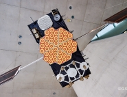
Satellites
Three types of satellite-based systems are contributing to the Cospas-Sarsat programme.
LEO satellites
Satellites in low Earth orbit (LEO), at an altitude of 800 to 1,000 kilometres, are the cornerstone of the programme and were the first to be launched starting in 1982, helping it to save its first lives that same year. These satellites form a system called LEOSAR. Their SAR Processors (SARP) calculate and log the position of distress beacons using Doppler processing techniques whose performance depends on the quality of the satellite’s ultrastable oscillator and a timing beacon located in Toulouse. The calculated data are downlinked in real time in a continuous loop to local user terminals (LEOLUTs).
LEO satellites take about 100 minutes to circle the planet. Due to its low altitude, a single LEO satellite cannot cover the entire globe in one orbital revolution. It therefore shifts from one revolution to the next according to a regular cycle, thus assuring global coverage. The more LEOSAR satellites are in orbit, the faster an alert will be downlinked to ground. The system is designed in such a way that four precisely phased LEOSAR satellites are able to deliver the required mission performance.
From the programme’s inception, France (through CNES), Canada and Russia have supplied the SARP instruments flown as passenger payloads on a range of Russian, American (NOAA) or European (Eumetsat) scientific Earth-observation and weather satellites. There are currently five satellites operational, but the constellation is starting to age.
GEO satellites
Geostationary (GEO) satellites orbit at around 36,000 kilometres and therefore have a wider field of view, complementing the LEOSAR system. However, their fixed position with respect to Earth means the Doppler effect cannot be used to obtain positional fixes.
They are simply repeaters and are therefore a useful complement to LEO readings to confirm a beacon code or position if the beacon has a GNSS receiver and sends its position in the transmitted message.
These GEO repeaters compose the GEOSAR system and have been launched on satellites with long mission lifetimes designed generally for weather services. They are operated by NOAA (USA), the Indian Space Research Organization (ISRO), Russia and Europe through Eumetsat (MSG and soon MTG satellites).
CNES provides support to Eumetsat on an as-needed basis for in-orbit validation of new GEOSAR repeaters and investigations in the event of an anomaly.
MEO satellites
Since the early 2000s and with the broad coverage of constellations of GNSS (Global Navigation Satellite System) navigation satellites, the best-known being GPS, the Cospas-Sarsat programme has been developing a MEOSAR system (for Medium Earth Orbit SAR) built around satellites orbiting at an intermediate altitude of around 20,000 kilometres, combined with compatible local user terminals (MEOLUTs).
The principle was first validated with the GPS constellation, and then soon after Europe added its contribution to the programme with its SAR Galileo component. Russia’s Glonass and more recently China’s Beidou are also prospective contributors.
This system, which will replace the LEOSAR system once the global ground segment of MEOLUTs and MCCs has been upgraded, affords a remarkable degree of reliability and performance, with instant detection of distress calls, increased redundancy of collection points and improved location accuracy.
Unlike with LEOSAR, which calculates positions on the satellite, it is the MEOLUT that guarantees location accuracy from the repeated onboard signal. Positional fixes are still obtained by measuring the Doppler shift: the MEOLUT must retrieve signals at any given moment from a maximum number of satellites within its line of sight and whose positions it knows from their ephemeris data. It achieves this by ‘pointing’ simultaneously at as many satellites as possible—at least four and preferably six—to ensure enhanced performance. This may involve up to six parabolic antennas each tracking a different satellite.
Another technology developed by CNES teams in partnership with Thales Alenia Space is an ‘active’ antenna consisting of a series of fixed elementary antennas and a processing chain capable of digitally replicating the equivalent of tens of parabolic antennas. An industrial version of this MEOLUT has been operating at CNES’s facility in Toulouse since end 2018 and is now being deployed at other sites around the world. The more-compact and easier-to-maintain terminal can detect beacons within a radius of at least 3,000 kilometres.

